Koh Kong is Cambodia’s most south-westerly province: a long, largely undeveloped coastline backed by the mountainous, forested Cardamoms. Its capital is Khemarak Phoumin, usually called Koh Kong town, near the Thai border.
Conditions now
Koh Kong
28°C
Partly cloudy · feels like 34°C
- Humidity 89%
- Wind 6 km/h
- Air: Good (AQI 36)
- TodayThunderstorms32° / 26°100% rain
- TueDrizzle30° / 26°100% rain
- WedThunderstorms29° / 26°100% rain
- ThuShowers29° / 25°100% rain
- FriShowers29° / 25°100% rain
Updated hourly. Forecast and air quality by Open-Meteo.com (CC BY 4.0). Conditions can change quickly in the wet season.
Why go to Koh Kong?
Come for nature. The province contains parts of the Cardamom Mountains, Botum Sakor National Park and the mangroves of Peam Krasop Wildlife Sanctuary. It suits travellers who want rivers, forest and coast rather than resorts.
What to experience
Peam Krasop mangroves
The mangrove forests near Koh Kong town can be explored on boardwalks and by boat. They protect the coast and support fishing communities.
Chi Phat
Chi Phat, in the southern Cardamoms, is a community-based eco-tourism project owned and run by the local community with support from Wildlife Alliance. Guided treks, cycling and homestays give income to people who once depended on hunting and logging. Book ahead through the project.
Rivers and waterfalls
Rivers such as the Tatai run out of the mountains to the sea, with waterfalls and river lodges along the way. Swim only where locals say it is safe; currents are strong in the wet season.
Islands and coast
Koh Kong Krao, Cambodia’s largest island, lies off the coast. Ask locally about boats and conditions, which depend on the sea.
How long should you stay?
Two nights let you see the mangroves and a river. Add one or two more for Chi Phat or a trek into the Cardamoms.
Getting to Koh Kong
Koh Kong town is about 250 km from Phnom Penh by road, a journey of roughly five to seven hours depending on the vehicle. The Tatai bridge and river lodges lie about 20 km from the town, with the Tatai waterfalls upstream by longtail boat. Phnom Aural, Cambodia’s highest peak at 1,813 m, rises in the Cardamom Mountains inland.
How to get there
- Compare operators and book BookMeBus · redBus Cambodia · 12Go · Baolau. These platforms list the operators on each route.
- From Phnom Penh (about 250 km) By road, roughly five to seven hours depending on the vehicle. Buses and minivans run this route; compare them on the platforms above.
- Around Koh Kong The Tatai bridge and river lodges are about 20 km from town; the Tatai waterfalls are reached upstream by longtail boat.
- Border crossing to Thailand Check the current status of the Thai crossing before planning onward travel.
Book through the operator, your hotel, or one of the platforms above. Cambodia Handbook is independent and not sponsored. Schedules change, so check the operator’s official website or office before you travel. Last checked 19 October 2026. See also transport booking and getting around Cambodia.
Planning notes
- Getting there: buses run from Phnom Penh and Sihanoukville; check current schedules.
- In the forest: go with a licensed local guide, carry rain protection and insect repellent.
- Thai border: the Cham Yeam crossing is a short drive from town, but the land border with Thailand has been closed or heavily restricted since June 2025 after clashes. Check your government’s travel advice and official announcements before planning any overland route.
- Fees and opening arrangements: confirm current details locally rather than relying on an old price or timetable online.
For planning, see our Cardamom Mountains guide and our Phnom Penh to Koh Kong route.
Koh Kong FAQ
How far is Koh Kong from Phnom Penh?
About 250 km by road, roughly five to seven hours.
What is there to do in Koh Kong?
Explore the Peam Krasop mangroves, visit the Tatai river and waterfalls, trek in the Cardamom Mountains or stay at the community-run Chi Phat project.
Can you cross to Thailand at Cham Yeam?
The land border with Thailand has been closed or heavily restricted since June 2025. Check official announcements before relying on it.
How long should you stay in Koh Kong?
Two nights cover the mangroves and a river; add one or two more for Chi Phat or a Cardamom trek.
Nearby provinces
Continue into a neighbouring province. See all 25 on our provinces of Cambodia page.
Sources: geography and protected areas from Koh Kong province (Wikipedia); Chi Phat from Wildlife Alliance and Chi Phat (Wikipedia). Distances and landmarks from travel sources. Last checked 4 October 2026.
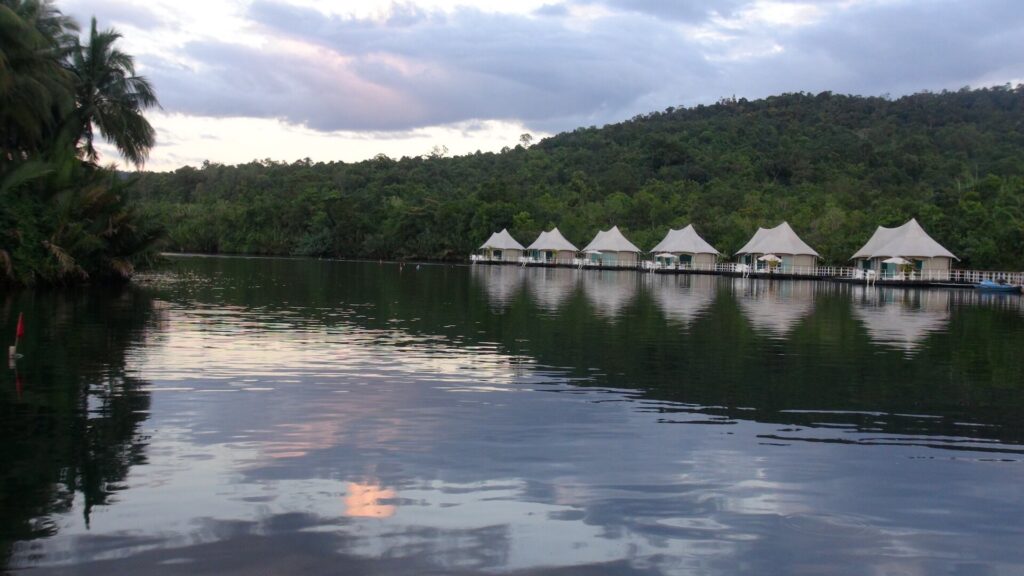
Featured image: Floating bungalows on the Tatai River, Koh Kong, by Dnrallis, licensed under CC BY-SA 4.0, via Wikimedia Commons.